
June 2, 2010 --Digital maps, satellite images and other forms of geospatial data are critically important for responding to disasters, protecting the environment and a host of other matters. But much of this information is in danger of being lost because of evolving technology and other threats.
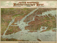
Panoramic view of New York City and vicinity. At head of map, Jacob Ruppert's Knickerbocker Beer. Geography and Maps Division, LC g3804n ct002193
The Library of Congress and Columbia University have agreed to create a web-based clearinghouse of information about best practices for preserving significant geospatial data. The National Digital Information Infrastructure and Preservation Program will fund development of the clearinghouse at the Center for International Earth Science Information Network (external link) at Columbia’s Earth Institute. CIESIN will launch a beta version of the clearinghouse later this year.
The clearinghouse is a direct outcome of a meeting held at the Library with representatives of the geospatial stewardship community in November 2009. A recurrent topic was the limited ability to learn about data stewardship advances, including new tools, methods and services that have potential for broad adoption. Participants were in agreement that leveraging best practices was essential to cope with explosive data growth in a cost-effective manner. There was also consensus that a web-based information service would be the best way to address the need.
For more information, see the Library press release about the project.